Wildfire Sensor
2nd place — TCD Provost's Sustainability Challenge, October 2026
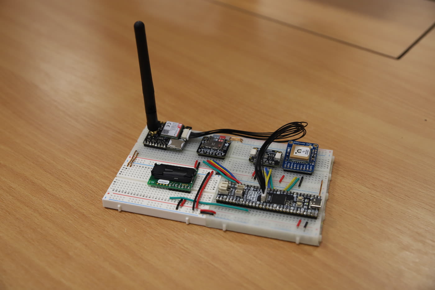
A prototype sensor that predicts wildfire risk for the exact spot where it's placed. It calculates the Fire Weather Index on the device, measures CO₂ to catch fires early, and sends its readings to a web server over LTE.
- Built
- November 2025 – March 2026
- For
- Leaving Certificate Computer Science coursework
- Stack
- MicroPython, Python, Flask, SQLite
- Result
- 2nd place, TCD Provost's Sustainability Challenge 2026 (team Oikos)
- Links
- Full write-up · Sensor code · Hackathon code
The problem
Ireland has a mild, wet climate, but wildfires are still common here. In 2025, 31 fires burned 4,355 hectares, more than six times the area of the Phoenix Park (EFFIS). Suppressing a fire and replanting costs €1,500–€2,500 per hectare (Maynooth University), so those fires could have cost €6.5–11 million.
Most detection systems only find a fire once it has grown. Infrared cameras and satellites need smoke to rise above the tree canopy, and the main fire-tracking satellites image the ground at 375 m–1 km resolution, only a few times a day. Sensor networks such as Dryad's Silvanet sit closer to the ground, but they estimate CO₂ from a general gas sensor rather than measuring it, and need their own LoRaWAN gateways to reach the internet.
I set out to build a sensor that could be deployed in a dense network, predict risk for its exact location, measure CO₂ directly to spot fires early, and connect without any extra infrastructure.
How it works
- Sensors
- Pico + FWI model
- LTE
- Flask + SQLite
- Web page
The model. The sensor predicts risk with the Fire Weather Index (FWI). It's a Canadian model, but it's used worldwide, including in Ireland, so the sensor's numbers can be compared with official ones. FWI combines temperature, humidity, wind speed, rainfall and day length into seven indices that track how dry the fuel on the ground is, how fast a fire would spread and how hard it would be to control.
I built the model first, since it didn't need any hardware. I converted the equations from Van Wagner and Pickett's 1985 FWI paper into Python, one file per index. Python meant the same code could run in MicroPython on the microcontroller.
Testing. I turned the paper's table of worked results into a CSV and wrote unit tests that compare each function's output against it, within ±0.3 to allow for rounding in the original FORTRAN. An integration test then ran the full model in sequence, feeding each stage's output into the next. Every case passed.
The device. The sensor measures temperature and humidity itself. For
rain and wind, it uses GPS to find the nearest Met Éireann weather station and fetches
that station's readings, which saved the cost of a rain gauge and an anemometer. Each
module has its own MicroPython file, and main.py ties them together: read
the sensors, fetch the weather, run the model, send the results. A high CO₂ reading
triggers an alert, since it can mean a fire has started nearby.
The server. A Flask app on an Ubuntu cloud server receives the readings as POST requests, stores them in SQLite and serves the latest data on a web page.
Hardware
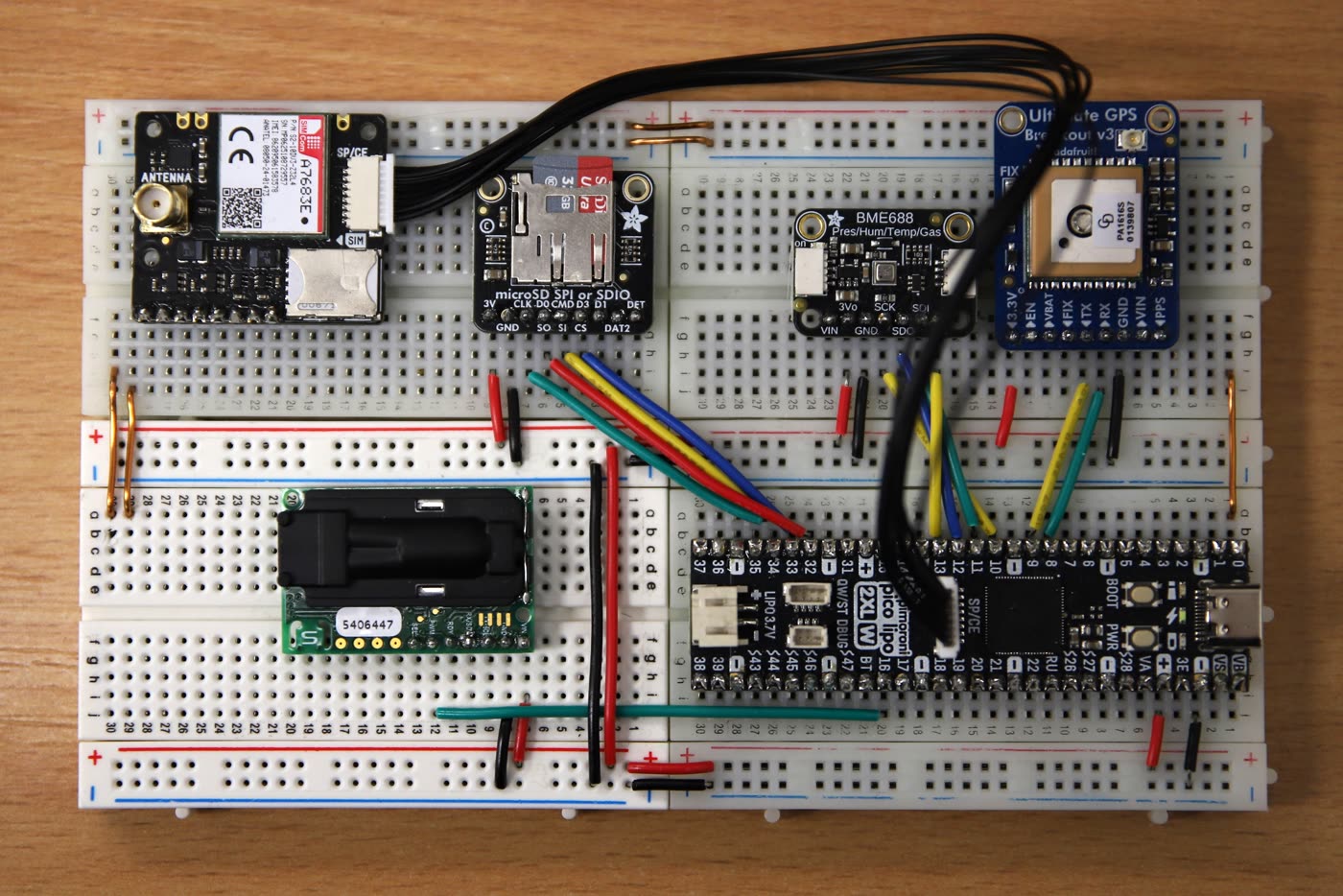
- Board
- Pimoroni Pico LiPo 2 XL W (RP2350), with built-in battery charging
- Weather
- Bosch BME688: temperature, humidity, pressure and gas
- CO₂
- Sensirion SCD-30: measures CO₂ directly (NDIR) rather than estimating it
- Location
- Adafruit Ultimate GPS
- Network
- Pimoroni LTE Clipper
- Storage
- Adafruit microSD breakout
Problems along the way
- The four breadboards kept separating, so I tied them together with copper wire.
- The BME688's connector cable broke after a few days, so I rewired it with header pins.
- The GPS rarely got a fix without an external antenna. The code now starts from a set location and replaces it once the GPS finds a signal.
- I couldn't get the SD card working. FWI needs the previous day's values, so I added a server endpoint that returns them instead.
- I chose LTE over LoRa to avoid needing gateways, but it turned out to be unreliable and power-hungry.
The hackathon
In October 2026, I brought the sensor to the Provost's Sustainability Challenge at Trinity College Dublin with my team, Oikos, and we placed 2nd. Over the event, we developed the idea into a minimum viable product, with a custom PCB and an enclosure. I designed the PCB, and I made sure the live demo worked: the prototype sent live readings to a dashboard and alerts to a phone.
What I'd do next
The original prototype works, but it lives on breadboards and isn't ready to leave in a forest. The hackathon's PCB and enclosure were the first step. Next, I would:
- Turn the PCB and enclosure designs into a unit that can survive weeks outdoors.
- Switch from LTE to LoRa for long-range, low-power communication.
- Add an external GPS antenna.
- Move the FWI calculation to the server, so each sensor can be simpler and cheaper.
- Replace SQLite with a database like PostgreSQL, so the server can handle many sensors.